|
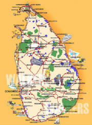
Map of Sri Lanka
formerly Ceylon, ancient Taprobane, officially Democratic Socialist Republic of Sri Lanka, population nearly 18,343,000
and 25,332 sq mi (65,610 sq km), located in the Indian Ocean, south of India.
|
 |
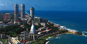
Colombo -The capital
largest city, population nearly 750,000 and capital of Sri Lanka, a port on the Indian Ocean. The city's major
sections are the old area of narrow streets and colorful market stalls; the modern commercial and government area around the
16th-century Portuguese fort; and Cinnamon Gardens, a wealthy residential and recreational area. Colombo has one of the world's
largest manmade harbors. Most of Sri Lanka's foreign trade passes through the port.
|
|
|
|
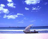
My home town - Galle
capital of Southern province, located extreme South Sri Lanka. An agricultural market center, Famous as a trade center
for Chinese and Arabs by 100 B.C. Galle was prominent under Portuguese rule (1507–1640), when
it became Sri Lanka's chief port. It was the capital of Sri Lanka under the Dutch (1640–56), whose original fort, built
to guard the harbor, still stands.
|
|
|
|
|
|
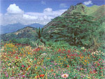
Hill country
In the higher elevations in hill country,it is quite cool with temperatures going down to 16°C
at an altitude of nearly 2,000 metres. Bright, sunny, warm days are the rule and are common and climatically Sri Lanka
has no off season.This cool green hills are the home of Ceylon tea.
|
|
